LiDAR, which stands for “Light Detection and Ranging”, is a remote
measurement technique that uses the light from a laser to determine the
physical properties of an object.
The vast majority of LiDAR sensor applications are for telemetry – distance
measurement.
To determine the distance of an object, the LiDAR sends a laser pulse to the
target.
The light is reflected on the surface of the object and sent back to the source.
The system then measures the time between the moment the light was sent
and the moment that it came back.
As the speed of light is constant, it can calculate the distance separating it
from the object.
The most sophisticated LiDAR systems can repeat this operation several
hundred thousand times per second!
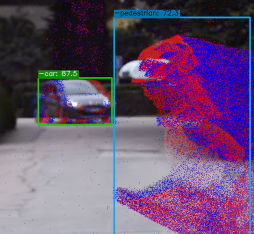
The data produced are converted into point clouds, which enable the
generation of highly-detailed maps or 3D-models of technical objects for
example.
LiDAR is used in a wide range of areas: topography, mineral exploration,
logging, civil engineering, architecture, or archaeology, etc.
Today, this technology is of particular interest to those involved in the
autonomous car, as LiDAR sensors could become the “eyes” of future
vehicles.
In effect, LiDAR makes it possible to detect obstacles tens of metres away
from the vehicle, and to map the surrounding elements, be they static or
mobile. This is essential to avoid collisions and facilitate the flow of traffic.
However, up until now, the high cost of LiDAR sensors has limited their mass
deployment, despite them representing a key innovation for the development
of autonomous vehicles.