Every day, billions of users turn to geolocation, a technology from the 1970s.
Up until 2009, all devices relied on American GPS technology. Competition and algorithms are changing the game.
Up until 2009, all devices relied on American GPS technology. Competition and algorithms are changing the game.
From the smartphone to the connected car, today geolocation is at the heart of our everyday lives and usages. With forty-five years on the clock, GNSS (Global Navigation Satellite System) technology can congratulate itself on having paved the way for thousands of applications and services used the world over.
Yet, technical limits and the development of competing technologies are now pushing engineers to imagine even more precise solutions.
Initially it was thanks to ground radio-navigation systems that the first innovations in the area of geopositioning were carried out.
Still in use today, in particular in the aeronautical sector, this system based on a radio signal sent by several transmitting stations proves to be precise at the local scale, but rapidly becomes imprecise at long distance due to the Earth’s roundness.
In 1957, the date pinpointed as the start of space exploration, the Soviet government launched Sputnik 1, the first of a long series of artificial Earth satellites. The American engineers quickly realised that the Doppler effect detected on the satellite’s signals made it possible to deduce its orbital parameters and therefore its exact position.
In 1964, the U.S. Army finalised the implementation of Transit, the first ever satellite positioning system in History capable of situating a receiver with a precision fluctuating between 200 and 1,000 m within a few hours, thanks to the signals and ephemerides of a handful of satellites put into orbit. A good start that paved the way for use by the general public.
Until then almost exclusively reserved for military use, geolocation technology became more accessible in 1995 with the entry into service of GPS (Global Positioning System), an American development initiated as early as 1974, whose precision relies on the presence of a network of at least 24 satellites of the NAVSTAR system orbiting the Earth at an average distance of 20,000 Km from its surface.
Radio waves sent from space at the speed of light enable the GPS receiver to quite easily deduce the distance of a satellite, thanks to the time of signal reception.
Through triangulation, it thus becomes possible to work out the exact geographical position of a receiver with a precision of around thirty metres. By opening this GPS technology up to civilians in 1995, the American government facilitated the democratisation of commercial geopositioning devices.
Advances in miniaturisation of GPS chips enabled the first model of geolocated mobile phone (the Benefon Esc!) to come about as early as 1999. The end of intentional degradation of the dedicated GPS signal as decided in May 2000 by the American government marked an important stage: notably facilitating the arrival on the market of onboard navigation devices combining GPS technology with “bird’s eye” view map interfaces. TomTom, with the TomTom GO in 2004, being the forerunner.
Presentation of Galileo, the European navigation system.
The dominant position of the United States in the geolocation-by-satellite marketplace incited the rest of the world to develop their own techniques.
Thus, Russia and China successively put into orbit GLONASS (24 fully operational satellites since 2011) and the Beidou 1 and 2 network (since 2000). The European Union has also been developing Galileo since the early 2000s, which is already operational and will be fully deployed during the year 2020 with 24 satellites in service.
Although these networks do not bring any particular innovations compared to the existing American technology, save that their recency ensures improved accuracy, they have considerably improved the quality of the data used today by most applications.
Thus, the iPhone 4S was the first smartphone to announce its compatibility with the GLONASS network in 2011. By compiling GPS and GLONASS signals the device can guarantee the user better reliability of positioning data.
In 2019, most devices also aggregate information transmitted by Galileo and Beidou. They are therefore based on an armada of American, Russian, Chinese, and European satellites, which facilitates signal quality improvement when transmission is imperfect. Such is the case in urban areas, where tall buildings and narrow streets create an “urban canyon” effect.
When the “urban canyon” phenomenon alters GPS signal quality in cities.
Up until now, the sometimes-relative acuity of GNSS technologies sufficed for users’ needs. With the advent of delivery service or carpooling applications, the error margin must be reduced further… to the scale of the centimetre in the industrial arena.
This is what Broadcom is promising with its BCM47755 chip, which for the first time combines data from the four international satellite networks with those emitted by a smartphone’s sensors (accelerometer, magnetometer, gyroscope).
In addition to these already highly ambitious innovations, are considerations around algorithms which, coupled with satellite signals, will revolutionise application precision.
Andrew Irish and Dany Iland, founders of the Shadow Maps startup acquired in 2016 by Uber, spend their time fighting GPS signal reflection, which is particularly strong in cities such as New York. The entire principle of their algorithm relies on the interpretation in three dimensions of a map and on inclusion of the signal’s distortion factor, the “signal-to-noise ratio” (SNR).
By considering signal deterioration, by projecting this information onto a map, and by adding a pinch of machine learning, it becomes easier for servers to send a driver the truly exact position of an individual situated on one or the other side of a street.
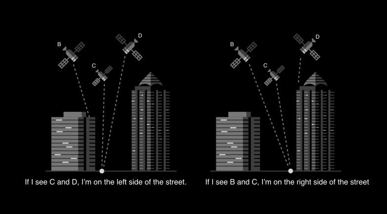
How the signal-to-noise ratio improves the Uber application
Although it may be impossible to change the technical architecture of the satellites sent into orbit over the past forty-five years, this method could make it possible in a very near future to obtain surgical precision for the whole set of everyday applications.