A Growing Trade and its Associated Problems
The explosion of e-commerce among individuals and the growing needs of businesses are contributing to a significant increase in the number of packages delivered downtown. This particular growth leads to others — the increase in greenhouse gas emissions, air pollution, road traffic accident analysis, noise and congestion [1]. In this context, last-mile delivery applies to the last stretch of the route between a logistics hub located on the outskirts of towns and the delivery addresses. These deliveries, which are largely outsourced, are carried out by delivery drivers who are in charge of a certain number of packages to be delivered to their recipient. For each delivery location, the delivery driver must find a parking space without being in violation of restrictions, then deliver the packages on foot from that location. A study carried out in Seattle [2] revealed that delivery drivers take an average of 2.3 minutes to find a place to park and that this search increases the duration of the route by 28%. In the wider Paris region of Île-de-France, more than 50% of deliveries were made by double-parking, parking in the cycle lane or parking on the sidewalk according to a survey carried out in 2015 [3]. These figures indicate the significant challenges and issues faced, not only in terms of the environment, but also by stakeholders such as logistic providers, local communities and residents.
The pooling of parking spaces for several deliveries makes it possible to reduce the distance traveled by vehicles, as well as the associated emissions, by up to 40%
Open Innovation Research on the Logistics of Tomorrow: The Physical Internet
The CIP (Chaire Internet Physique) [6] is a Physical Internet research chair supported by the CGS (Centre de Gestion Scientifique — scientific management center) at the MINES Paris-PSL educational institution in France. Founded in 2016, it entered its second phase in 2020. Funded by several companies (GEODIS, GS1 France, Orange and P&G), its research program aims to develop empirical and theoretical research on the Physical Internet. The CIP focuses on theoretical work concerning the interconnection of logistic services on the one hand and testing interconnected solutions on the other. The program centers on two main themes: logistic networks and innovative services, and the study of a theoretical framework for the Physical Internet, including two areas of application — sustainable urban logistics, which we are discussing here, and major international exchanges.
The concept of the Physical Internet [4] is to apply the principles of the Internet to logistics — to create a global, open, interconnected network using a set of collaborative protocols and standardized intelligent interfaces to deliver physical goods contained in standard modules ({physical packages, their suppliers, their customers, routes, logistic coordinators}) in the same way that the Internet delivers “packets” of information ({IP packets, their transmitters, their recipients, routes, routing tables}). The goal is to establish a more resilient, efficient and sustainable open global logistics system by interconnecting logistic networks for end-to-end logistic services. This paradigm was cofounded by researchers at MINES Paris and Georgia Tech in the United States, and is currently a key lever in achieving the objective of net-zero logistic emissions in Europe, according to the ALICE roadmap [5].
The collaboration between MINES Paris-PSL and Orange includes experimenting with the use of digital twins to help with sustainable urban logistics and, more specifically, the last mile problem. A doctoral thesis focusing on this concept was supported in December 2022 (with Orange participating in the thesis jury) [7, 8, 9]. The work focused on several research questions — the modeling of digital twins for logistic systems, the interoperability and integration of systems into the digital environment of smart cities, and the modeling of decision-making in this context.
Application: Optimizing Delivery Routes
In this approach, the objective is to help delivery drivers find places to park (referred to as parking spaces below for simplification), as well as to reduce the carbon footprint of delivery routes. Using a mobile app, delivery drivers will be able to find available spaces where they can park to make a delivery in advance. To reduce the distance traveled by a vehicle, the system pools the parking spaces, i.e. it looks for spaces that can serve several destinations at once.
In order to assess the benefits related to the consolidation of deliveries via parking spaces, the following KPIs are calculated:
- delivery distance — the number of miles driven by the truck;
- delivery time — time spent walking and driving, as well as package delivery times;
- delivery cost — the total cost consisting of the cost of the vehicle (fuel and use) and the cost of the delivery driver (salary), depending on the time and distance traveled;
- greenhouse gas emissions — calculated by CO2 emissions per vehicle-mile multiplied by the delivery distance.
A Digital Representation of the Environment: The Digital Twin
Digitalization needs are growing in all sectors in the search for more fluid business processes, increased productivity or better control of environmental impact. A digital twin provides a digital representation as a synchronized, updated model of a physical environment (here the physical elements involved in a delivery — the packages, parking spaces and delivery addresses), the business processes that will take place using the physical infrastructure, and the interactions that take place between the different participants in the chain.
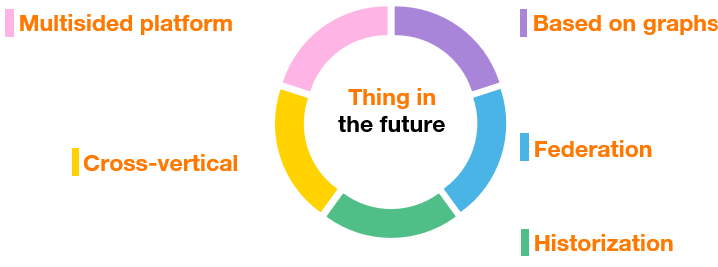
Figure 1 — Characteristics of the Thing’in digital twin platform
To model these digital twins, we use Thing’in, a testing platform for digital twins developed and tested over several years through Orange’s research, which offers the five main characteristics illustrated in Figure 1:
- Cross-vertical: Thing’in can address different use cases in different verticals, such as smart cities [9], smart buildings [10], smart industry, etc. Thanks to its highly versatile data model, users can use existing models on Thing’in or import their own model. This also makes it possible to address use cases that mix different verticals.
- Multisided: The platform allows participants to unite within the same vertical or across different verticals. Each participant can choose what is shared and with whom. Thing’in allows you to define fine-grained access controls, up to the ownership of a digital twin.
- Based on graphs: Thing’in relies on graph modeling to capture the structure and semantics of real-world entities. Graphs offer both an extremely simple and highly powerful formalism that allows for the modeling of all kinds of entities, from simple objects to complex systems (e.g. a factory), as well as systems of systems (e.g. a city, or a logistics or telecommunications network). These graphs are synchronized with the real world they represent.
- Federation and distribution: The platform can be divided into different instances distributed in the cloud and/or at the customer’s premises, thus forming a federation of instances where each one can communicate with the other instances in the federation, if the managers want it to. Plus, access controls are not the same within the federation as within a platform. This means users can choose to share certain information within their instance and only a subset with the federation.
- Historization: Digital twins are historized; it is possible to know the state of digital twins in the past.
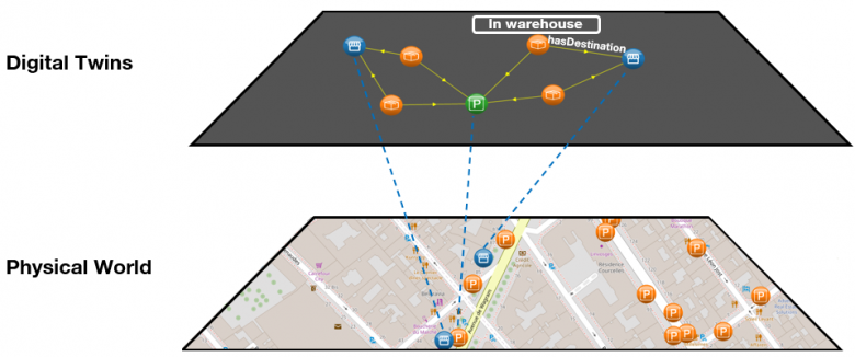
Figure 2 — Digital twins for last-mile delivery
Optimizing Delivery Routes Using Digital Twins
In the demonstration illustrating the prototype, the parking spaces, destinations and packages are modeled as digital twins. The parking space data comes from Open Data Paris, the “delivery” type of parking spaces in the 17th arrondissement in Paris and the neighboring parking spaces are also modeled as graph-based digital twins in Thing’in. Each parking space has the following properties: the status, which allows you to see if the parking space is available or not (in this demonstration, the assumption is made that parking spaces are equipped with sensors), the address and the GPS coordinates. The destinations come from the “addresses” dataset from Open Data Paris, where each destination has GPS coordinates and a postal address. For each destination, a set of packages is generated according to the Pareto principle, i.e. that certain destinations will have many related packages and most destinations will have limited related packages. Each package has a barcode, a status (“at the warehouse,” “in transit” or “delivered”) and is associated with a destination through a relationship. Figure 2 illustrates the relationship between the digital twins and the physical world. For example, connected parking spaces in the physical world allow the delivery driver to know if parking is available or not using the digital twin.
Unlike a classic last-mile delivery system, this demonstration not only focuses on the use of parking to help delivery drivers with their work, it also consolidates deliveries via parking spaces to reduce the carbon footprint and noise pollution of deliveries. This requires adding two stages to the traditional process — a choice of parking spaces and setting the order of visits to these spaces. These two stages can be completed using the digital twins on the Thing’in platform. The choice of parking space is itself divided into two substages — the list of parking options and the choice of parking space. The list of parking options for each destination is established using the digital twin. For each destination, the Thing’in platform allows us to find parking spaces within a specific radius (e.g. 100, 200 or 300 meters). At the end of this stage, each destination has several parking options, i.e. delivery drivers have several options for parking their truck and making the deliveries. The aim of the second stage is to pool the use of parking spaces by consolidating packages in order to reduce the environmental impact of deliveries. At the end of this stage, each package for a destination is linked to a single parking space, with one parking space being able to serve multiple destinations.
Then, the order in which to visit the parking spaces needs to be determined. The digital twin makes it possible to determine which parking spaces are retained. These are then used as input data for a heuristic that makes it possible to establish the order of visits to parking spaces. Several heuristic algorithms exist to solve the so-called traveling salesman problem [11]. These heuristics are approximate methods that allow for a quick and satisfactory solution, even if it is not necessarily the optimal solution. In our case, we are using the elastic-band method where each parking space is a point. You place the elastic band in the center and the goal is for it to cover all the fixed points (parking spaces), while making sure the elastic is as taut as possible [12].
During the route, the status of the parking space digital twin is updated in real time, assuming that the parking spaces are equipped with sensors. The system can use this information to update the delivery route in the event that parking is no longer available.
Application was first simulated on a multi-agent simulation tool using the dataset, with the objective of quantifying the potential benefit [7]. The digital results show that the consolidation of deliveries via parking spaces reduces the distance traveled by vehicles by up to 40%, which in turn reduces vehicle emissions. However, consolidation through a wider parking radius (i.e. increasing the distance between a destination and a parking space in order to select parking options) leads to lengthening the delivery driver’s walking distance. To reduce the time delivery drivers spend walking, the last few meters could be covered by bike couriers for example.
Other Route Optimizations Are Possible to Widen Perspectives
This first demonstration offers a first use case of implementing digital twins in sustainable urban deliveries. Other use cases are possible and, for the case described above, several improvements in route management have already been identified. The first is to add new constraints, for example, the weight of packages, delivery windows for packages, destination opening times, etc. A second avenue is to extend use to multimodal transportation, such as bike couriers or ferries. These avenues have been explored in the collaborative European project ASAP (Awaken Sleeping Assets Project [13]) involving Orange and MINES Paris-PSL, as the use of soft mobility would reduce the carbon footprint of deliveries. The third avenue is collaboration between delivery drivers. In the event that a delivery driver is running late, they could call on other delivery drivers who have already completed their routes to help out by using proactive digital twins. For example, packages could automatically detect that the delivery driver is running late for their delivery and—without the intervention of delivery drivers other than a request for consent on their behalf—autonomously organize the process of mutual assistance between drivers. This would help mitigate external events and improve customer satisfaction.
Sources :
[1] Handbook on the external costs of transport (2019), https://op.europa.eu/en/publication-detail/-/publication/9781f65f-8448-11ea-bf12-01aa75ed71a1
[2] G. Dalla Chiara and A. Goodchild, « Do commercial vehicles cruise for parking? Empirical evidence from Seattle », Transp. Policy, vol. 97, pp. 26–36, 2020, doi: 10.1016/j.tranpol.2020.06.013.
[3] L. Dablanc, « Parking for freight vehicles in dense urban centers – The issue of delivery areas in Paris ». (https://www.metrans.org/assets/research/MF14-3%202d_Parking%20for%20Freight%20Vehicles%20Final%20Report_070815_0.pdf)
[4] Le concept de l’Internet Physique, https://www.cip.minesparis.psl.eu/concept-de-linternet-physique/
[5] ETP-ALICE, https://www.etp-logistics.eu
[6] La Chaire Internet Physique, https://www.cip.minesparis.psl.eu/
[7] Y. Liu. « Cognitive Smart City Logistics: a new approach for sustainable last mile in the era of digitization ». 2022, Thèse. Mines Paris-PSL Université
[8] Liu, Y., Folz, P., Pan, S., Ramparany, F., Bolle, S., Ballot, E., & Coupaye, T. (2021). Digital Twin-Driven Approach for Smart City Logistics: The Case of Freight Parking Management. In Advances in Production Management Systems. Artificial Intelligence for Sustainable and Resilient Production Systems: IFIP WG 5.7 International Conference, APMS 2021, Nantes, France, September 5–9, 2021, Proceedings, Part IV (pp. 237-246). Springer International Publishing.
[9] Liu, Y., Pan, S., Folz, P., Ramparany, F., Bolle, S., Ballot, E., & Coupaye, T. (2022, November). Connected Freight Parking in Smart City Logistics. In 9th Transport Research Arena TRA Lisbon 2022 (TRA2022).
[9] https://mastermedia.orange.com/publicPlaylist?t=plbm9w4I5Df&o=4632
[10] https://hellofuture.orange.com/fr/le-futur-des-batiments-intelligents-avec-thingin/
[11] https://fr.wikipedia.org/wiki/Probl%C3%A8me_du_voyageur_de_commerce
[12] https://interstices.info/le-probleme-du-voyageur-de-commerce/
[13] ASAP, http://www.smarturbanlogistics.eu
 Yu Liu


